Visiting the “Wuthering Heights” locations
For those of you who want to make a 'pilgrimage' to visit the sites connected with Emily Brontë and Wuthering Heights, I have created this page. I visited most of the sites in September 2008 and revisited some in January 2011, and the contents here refer to my visits then. I cannot guarantee that some things may not have changed in the meantime – if you find any errors or inconsistencies, please let me know and I will amend them.
If you have a GPS which can accept GPX files, you can download the locations to add as waypoints: right-click here and choose "Save Link as/Save target as".
A GoogleMap showing Wuthering Heights and Emily Brontë locations can be seen by clicking on the image left or here.
Haworth
Haworth would be pretty much unknown outside of the local area if it were not for the Brontë family and the higher area of the town is very much tailored to tourism.
Brontë-related sites are all at the top of the town which sits at the end of a very steep, cobbled road (Main Street). If you have the time and energy, it is worth visiting Haworth by climbing this road which gives you some feeling of how the town must have seemed to the Brontës when they arrived in 1820 (not that they would have seen the "Jane Eyre tea shoppes" of course). However, if that climb is not possible, there are three car parks at the top of the hill. The private one at Changegate (opposite the Brontë Weaving Shed) is notorious for its ultra-strict clamping rules so be warned!
If, like me, you would prefer to walk than pay to park, you can choose the option I made on my visit. Behind the Parsonage runs Cemetery Road which has several lay-bys for visiting either the cemetery or the moor. You can park here for nothing and walk the short distance (five to ten minutes) to the Parsonage. As well as being free, you avoid the tourist areas as you make your way to the Parsonage so have a 'purer' image of the town. Walking past dozens of tea shops and gift shops can ruin the atmosphere of a historical site.
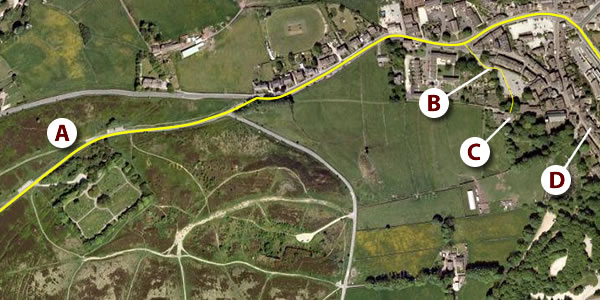
Aerial View of the upper approach to Haworth (© Google Maps)
(A) parking area on Cemetery Road; (B) path to the Parsonage through the car park;
(C) the Parsonage; (D) Main Street
Top Withens and the Brontë Waterfall
See also the Top Withens page and the Other Locations page.
 Click to enlarge
Most people combine a visit to the waterfall and Top Withens since they are on the same popular path. You can leave from the Parsonage but, if you want to save your legs, you can park (or catch a bus) closer. The best place to park is on Moor Side Lane which runs between Stanbury and Oxenhope. There are several free areas to park, one with a toilet. Opposite the toilets is a path marked Top Withens but this by-passes the waterfall so, unless you want to ignore it, head north a short distance from the toilets until you find a path marked "Footpath to Bronte Waterfalls" (directly opposite the road to Haworth: see picture right). The path to the waterfall and Top Withens is generally good although you can come across some wet sections, especially away from summer, so good boots are wise.
An OS Map of the Paths to Top Withens (© Ordnance Survey)
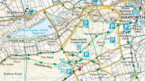
In the map above, the blue PC at the bottom marks the parking area with the toilets. The path directly to Top Withens is the green dotted line heading off south-west at the bottom. The two dotted green lines heading off to the left (one marked 'Millennium Way' and the one above 'The Slack') are the correct paths if you wish to visit the Falls. You can also see the path directly from the Parsonage.
There is a shorter, alternate route from Ponden Hall passing Ponden Kirk. However, this avoids the waterfall. It is not such a clear route and the ground is more difficult.
| Location | Latitude | Longitude | OS Reference | Altitude | |
|---|---|---|---|---|---|
| Top Withens | 53° 48.9′ N | 2° 1.8′ W | SD 981 353 | 413 m | |
| Brontë Waterfall | 53° 49.1′ N | 2° 0.2′ W | SD 998 358 | 302 m |
A location map of Top Withens can be seen here and the aerial view here. It is also marked on the Google Map of Emily Brontë/Wuthering Heights locations.
Ponden Kirk
See also the Ponden Kirk page.
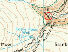
Ponden Kirk, the likely inspiration for Penistone Crags, is not the easiest place to find. The OS map (right) suggests that it is on the east side of Middle Moor Clough valley when it is on the west, something that nearly caused me to miss it when I visited. I have marked the Kirk with a red circle on the map. It is easiest if you have a portable GPS and use the map references and the aerial map below.
It is not too difficult to see the Kirk from a distance (although walking boots and good clothing are necessary in all but the best weather). If you wish to get close to the rock and even stand upon it, take care. The path that runs around the top of the valley sides is narrow and uneven with a steep drop alongside at times (although you can cut across the top via the sheepfold: a compass or GPS is invaluable then).
The Kirk can be reached from Top Withens by walking north over the hill (Delf Hill) above the ruin or from Ponden Hall. A location map of the rocks can be seen here and it is also marked on the Google Map of Emily Brontë/Wuthering Heights locations.
| Latitude | Longitude | OS Reference | Altitude | |
|---|---|---|---|---|
| 53° 49.5′ N | 2° 1.9′ W | SD 979 364 | 384 m |
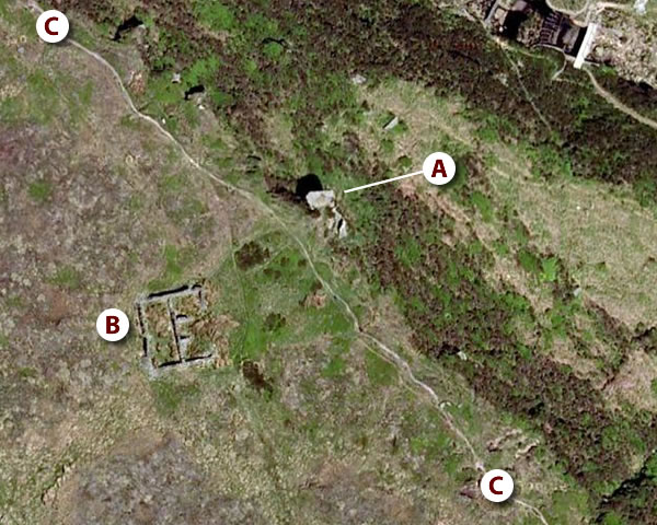
Aerial View of Ponden Kirk (© Google Maps)
(A) the Kirk; (B) sheepfold; (C) the narrow path that passes the Kirk
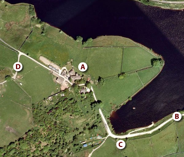
Ponden Hall
See also the Ponden Hall page.
Not being on the moor itself, Ponden Hall is quite easy to get to by car, bus or cycle (it is a fair walk if you are coming from Haworth, about 4.2 km/2.6 miles from the Parsonage). You follow the Haworth to Colne road and turn off south at a junction just over a bridge: there is a mill/gift shop (which is easier to spot). Do not stop there (unless you want to) but drive past it around the reservoir. If you are coming by bus, the stop is "Ponden Mill".
Note that the road from the main road to the Hall is in a poor state of disrepair and you will need to drive very slowly and carefully. (Think army tank training course!)
There is little room to park by the Hall so you should park further back and walk the final short distance. A location map of Ponden Hall is here and it is also marked on the Google Map of Emily Brontë/Wuthering Heights locations.
| Latitude | Longitude | OS Reference | Altitude | |
|---|---|---|---|---|
| 53° 49.8′ N | 2° 0.9′ W | SD 990 370 | 245 m |
Aerial View of Ponden Hall (© Google Maps)
(A) the Hall; (B) path from the main road; (C) space to park; (D) path to Ponden Kirk